Feeds:
Posts
Comments

Archive for the ‘Cow Bay’ Category

Paving Paradise

child walking on gravel road

You can’t stop progress.  Maybe that’s true.  But what is considered progress to one person is not necessarily the same for everyone.

In a province where elected officials and bureaucrats are especially sensitive to  being called ‘backwards’ and ‘backwoodsy,’ on December 10th 2013, Halifax Regional Municipality Councillors voted unanimously to pave five gravel roads in the Flandrum Hill subdivision.  Although property owners had been formally surveyed by HRM last Spring and the majority voted against paving the roads, Council decided they knew what was best for  HRM. Since HRM’s own policy recommends that a minimum of 50% of the residents must be in favor unless it is in the best interest of HRM, one wonders what interests would be so great as to override the wishes of the majority?

view from the top of flandrum hill road

View from the top of Flandrum Hill Road

Of course such decisions are easier to make when you’re not a homeowner looking at a $6,500.00 bill (calculated at $35 per linear foot of frontage).  It’s also easier when you don’t have to consider environmental impact.  An environmental study was not undertaken.  However, that doesn’t mean the environment won’t be affected.

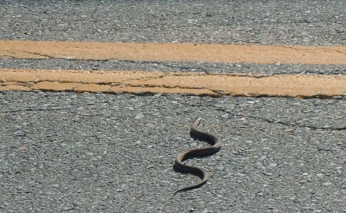
snake-crossing-cow-bay-road

Maritime Garter Snake crossing Cow Bay Road in summer

When warmed by the sun or tire friction, asphalt releases harmful greenhouse gases. During the paving process, fumes from the oil used to bind the aggregate are known to cause sickness in humans.  Might be a good idea to keep children indoors when the roads are paved later this summer.  Somebody ought to give the wildlife a heads-up too.

ditch along flandrum hill roadDrainage considerations have to also be addressed with paved roads due to potential problems with run-off. Unlike a gravel road, pavement does not absorb precipitation. Though this isn’t as much of a concern for folks who live at the top of a hill, paved roads can potentially contribute to flooding in low-lying areas.

Drivers are known to speed more on paved roads than gravel ones. With its steep incline, Flandrum Hill Road will most likely see an increase in speeding.  Woe to the children who get in their way!

The cost of neglecting asphalt can be scary. Repeated freezing and thawing over the winter months takes a regular toll on all our Nova Scotia roads.   It’s one thing for homeowners to share in the cost of paving roads initially, but what happens when a municipality has to bear the burden of increased maintenance costs without raising taxes? In recent years, some counties in the U.S. have converted their paved roads to gravel once again.  See:  Roads to Ruin:  Towns Rip Up the Pavement

Many of us moved here because we liked the idea of living closer to nature.  We have no bus service and we’re still on well water and septic.  Gravel roads just seem to be another part of a lifestyle that the majority of us consider simply part of rural living.

Progress means getting nearer to the place you want to be. And if you have taken a wrong turning, then to go forward does not get you any nearer.
If you are on the wrong road, progress means doing an about-turn and walking back to the right road; and in that case the man who turns back soonest is the most progressive man.
~ C.S. Lewis

All photographs and text copyright Amy-Lynn Bell 2014

Read Full Post »


The seasons wait for no one.  In Nova Scotia, this is especially true with our springs and summers, which always seem too short. 

Looking back on a summer that flew by more quickly than most, I notice myself scrambling to find a few small things to take with me into the cooler seasons ahead.   There may not have been any long hot days at the beach to look back on, but that’s ok…

Sometimes, the smallest things take up the most room in your heart.

~  Winnie the Pooh 

Children playing in the sunshine, a warm breeze enjoyed while hanging out the laundry and flowers glimpsed coloring the wayside… these are the little things that will still provide warm memories of summer next January. 

Perhaps it’s their vulnerability that endears these small things to us.  Wild roses growing on the edge of a busy road…

Or tiny caterpillars crossing the trail…

Perhaps it’s because the blooming time for many small wild things is limited to just a couple of weeks a year.  

 Come the dark days of November, their presence will seem to have been as fleeting as that of a butterfly.

And the rising summer sun a brief kiss of light.

Is it so small a thing
To have enjoyed the sun,
To have lived light in the spring,
To have loved,
To have thought,
To have done?
~ Matthew Arnold

This post was inspired by Summertime written by Isabelle at Isathreadsoflife’s Blog.

Read Full Post »

What can the rest of us learn from this past day’s disaster in Japan?  Watching live footage of the tsunamis devastating the landscape, or fires burning at refineries, you can’t help but wonder if your community would fare any better. 

People in many countries along the Pacific Rim have been warned to move to 50 feet above sea level (6 floors in a building) in wake of the threat of tsunami waves hitting their shores.  To a greater or lesser extent, coastlines around the globe will all eventually feel the ripple effect of the 8.9 earthquake that originated just off the coast of Japan.

I once saw a television crew set up in the location pictured above, filming a forest fire along the eastern shore that was blazing across the water.  Viewed from a safe distance, disasters can be mesmerizing, but experienced up close, they’re a different story altogether.  At a recent workshop on climate change held in Eastern Passage, one of the questions residents were asked was what our evacuation strategy would be in the event of a disaster.  What roads would we take in order to reach safety? 

Once again, watching live footage taken from a helicopter of the disaster in Japan today, it was clear that many vehicles were travelling on roads that were leading towards disaster instead of away from it.  From the ground, it’s often difficult to determine the best route to safety.  A prepared plan of action would make a big difference in a crisis situation.

Be Prepared… the meaning of the motto is that a scout must prepare himself by previous thinking out and practicing how to act on any accident or emergency so that he is never taken by surprise.

~ Sir Robert Baden-Powell

Is your household prepared for disaster of any type?  If you live along the coast, do you know if your elevation is low enough to require evacuation in case of flooding?  If you had to evacuate, what route would you take?  Where would you go, and would you have enough gas in your vehicle to get you there?  It’s never too early to make plans to seek higher ground. 

If you would like to find out the altitude of any point on the planet, an application that makes use of Google Maps can be found at Daft Logic.

For more information on emergency preparedness in Nova Scotia, see Nova Scotia Emergency Management Office.


Read Full Post »

And part of the soil is called to wash away
In storms and streams shave close and gnaw the rocks.
Besides, whatever the earth feeds and grows
Is restored to earth. And since she surely is
The womb of all things and their common grave,
Earth must dwindle, you see and take on growth again.
~ Titus Lucretius – On the Nature of Things (1st century BC)

When Captain James Cook charted Cole Harbour on a map of Nova Scotia in the mid-1700s, it was wide and deep enough for tall ships to sail in and out.  Though not as large as Halifax Harbour, it still saw its share of commercial vessels and privateers.

But over the centuries, shifting sands have narrowed the entrance to Cole Harbour.  The harbour seems more like a marsh these days, leaving many residents to wonder about the exact whereabouts of Cole Harbour.  Passage through the entrance is seldom undertaken by vessels of any size due to the strong currents.  Though we might bemoan the recent evidence of erosion along Rainbow Haven Beach,  in Cook’s time, this spit of land didn’t even exist.

Part of a Nova Scotia map by James Cook showing Cole Harbour at far right

In A Tale Of Two Dykes – the Story of Cole Harbour (1979), Margaret Kuhn Campbell explained:

A coast line so irregular seems to fling a challenge to the great energy of the ocean.  It hurls itself at the indentations to remove them – tearing down headlands, filling in bays.  Hartlen Point west of Cow Bay and Osborne Head on its east are two drumlins presently being eroded by the sea.  At the mouth of a bay, it seeks to build a fishhook shaped spit anchored on the curved shore with its point reaching toward the other, constantly growing, until in time it may close the gap.  Then the bay becomes a protected lagoon which catches silt from streams, grows grasses, and thus traps more silt to eventually become marshy to dry land.  Through centuries of toil, the powerful waves compounded such a barrier part way across the mouth of Cole Harbour.

Erosion at Rainbow Haven Beach

The increased frequency of severe storms in our area means we will see more rapid changes to our shorelines in the years ahead.  While some beaches will suffer erosion, others will widen.  The extent to which man can halt or alter these transformations is questionable.  What is inevitable is that these changes will surely affect wildlife as well as residential, recreational and business developments along our coast.

On February 17th, HRM will be hosting a Climate Change Workshop for Eastern Passage and Cow Bay residents.  Details of the event can be found at Eastern Passage Online. 

Read Full Post »

If you dug a hole straight through to the opposite side of the planet, where would you come out? Like most North Americans, Nova Scotians would find themselves in the middle of the Indian Ocean. 

Wherever we live on the planet, we tend to think of our immediate environment as stale and mundane compared to what lies beyond the horizon.  The intrigue of the unknown is fascinating to us all.  If we live where it’s cold, we long for tropical weather and dislike having to shovel snow or drive on icy roads.  Desert and tropical inhabitants long for cool fresh air and wonder about the magical qualities of snow.  We humans are a tough lot to please.

The part of the Indian Ocean where Nova Scotians would find themselves is just southwest of the Great Australian Bight, an area inhabited by marine creatures, the majority of which (like the leafy sea dragon at left) are only found in that part of the world.  Now THAT is fascinating.  Though they are pretty cool too, I believe all the plant and animal species found here in Cow Bay are found elsewhere in Canada and the United States.

Photo credit:  Traci Woods Wellington AustraliaAs luck would have it, there actually exists another Cow Bay in Queensland Australia.  Located in the Daintree Rainforest, it boasts an average annual daily temperature of 27 Celsius.  We don’t even enjoy that as an average during our summer months.  But it rains there 120 days of the year.  As evidenced by the phenomenal flooding that’s wreaked havoc in Queensland recently, no place on the planet is likely perfect.  But that won’t stop me from wondering about faraway lands (and waters) and the amazing creatures that inhabit them. 

Photo credits and references:

You can try Zefrank’s Earth Sandwich tool for yourself by clicking on the map images at the top of this post.

A larger version of the photograph of the amazing leafy sea dragon by Laurent Ballesta and other marine wildlife found off Australia’s coast can be found at National Geographic by clicking on the dragon image above.

More images of the flooding in Queensland can be found by clicking on the image of the kangaroo ferryman photographed by Traci Woods.  Thank you to Dawn at Sahlah Photos and Thoughts for inspiring me with her post on Flooding in Queensland.


Read Full Post »

Half hidden among the rocks, nuggets of fool’s gold often catch my eye as I’m walking in Cow Bay.  Also known as pyrite, fool’s gold is found in cubic forms with lustrous facets that lead many to believe they’ve discovered something far more precious. 

But there was a time when real gold was found in Cow Bay.  The story of gold’s presence here reveals a little known connection to Africa and begins around the time of the earliest fishes. 

Five hundred million years ago, there existed a proto-Atlantic Ocean.  North America and Africa were separate from one another, as they are today.  Back then, gold bearing sediments were carried by rivers in Africa, accumulating along the shore.  A hundred million years later, sedimentary layers crumpled as North America and Africa collided during the time of Pangaea.  The metamorphic process began to concentrate the gold.

The break-up of Pangaea

Two hundred million years ago, around the time of the earliest dinosaurs, the present Atlantic Ocean was formed as North America and Africa separated during the break-up of Pangaea.  When this took place, part of Africa remained attached to a section of Nova Scotia.  Gold-bearing rocks known as the Meguma Group are found in this section.  Sedimentary rocks in the Meguma Group include the Goldenville Formation (sandstone and greywacke) and the Halifax Formation (slate).

During the late 1800s, gold sediments were found near the Cow Bay River.  Shortly afterwards, a mill was constructed and mining began.  The gold mine in Cow Bay was one of 67 in the province, all mostly located along the Eastern Shore.  Mining in Cow Bay was abandoned in the 1950s.  Supposedly, there are still some open mine shafts to be found in the woods. 

A couple of years ago, while panning unsuccessfully for gold in the Cow Bay river, I wondered about the excitement others must have felt when they found the real thing.  It sparks the imagination to think that the people of Cow Bay share common ground with the people of West Africa.  The world is full of wonders, just waiting to be unearthed.

This post was inspired by an essay my son Kip wrote in grade 8.  The information he compiled is from unknown sources.  Please let me know if any of what is written above is incorrect or can be credited to a known source.

A pdf map of Historical Gold Mining in the Cow Bay area can be found on the Government of Nova Scotia website here.

Read Full Post »

Older Posts »